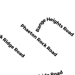
135 RANGE HEIGHTS RD
Owner Information
FAIA CHARLES D
135 RANGE HEIGHTS RD
LYNN, MA 01904


Property Details
135 RANGE HEIGHTS RD is classified as a Single Family Residential (Colonial).
The primary structure on this property was built in 2004. There are 2,590ft2 of built area within this property. There is 2,590ft2 of residential/living space within this property.
135 RANGE HEIGHTS RD is valued at $800,200. The land is valued at $184,900 and the structures are valued at $598,400. There is an additional valuation of $16,900 on this property.
This property is in Zone R1. Confirm with local Zoning Board authorities to ensure there are no overlays or other easements on this property.
The most recent deed for 135 RANGE HEIGHTS RD is recorded at the local registrar in Book 22778, Page 85. 135 RANGE HEIGHTS RD was last sold on Monday, May 3, 2004 for $148,500.
Assessment data from fiscal year 2022.
Flood Data
According to the FEMA National Flood Hazard Layer, this property does not appear to be in a flood zone. It may also be in an area not yet reviewed. Nonetheless, confirm this information prior to taking any action.
To view the flood hazards around this property, create a FEMA "Firmette" Map of the area around 135 RANGE HEIGHTS RD.
Broadband Internet Providers
| Provider | Type | Bandwidth (mbps) | |
|---|---|---|---|
| Verizon New England Inc. | Fiber | 940 | 880 |
| GCI Communication Corp. | Satellite | 0 | 0 |
| HughesNet | Satellite | 25 | 3 |
| VSAT Systems, LLC. | Satellite | 2 | 1 |
| Viasat Inc | Satellite | 100 | 3 |
| Verizon New England Inc. | DSL | 1 | 0 |
| Comcast | Cable | 1000 | 35 |
Broadband service provider data from December 2020.
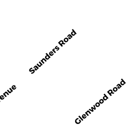
Adjacent Properties
- 0 PHAETON ROCK RD
Undevelopable Residential Land owned by BRADY EDWARD J - 49 SAUNDERS RD
Two-Family Residential owned by SATTERWHITE MICHAEL ANTHONY - 43 SAUNDERS RD
Single Family Residential owned by PALMITESTA JAMES M - 37 SAUNDERS RD
Single Family Residential owned by JEAN-PIERRE STEPHAN - 136 RANGE HEIGHTS RD
Single Family Residential owned by EVELYN REXINIS TRUST - 131 RANGE HEIGHTS RD
Single Family Residential owned by SEVINC VAHIT